Suðurland {South Iceland}
The south is the most visited area in Iceland. The streets are traversable year round and let the visitors enjoy the beauty of nature in all varieties.
The coast is truly beautiful with black sand and incredible stone formations. The contrast between the sea and the mountains is breathtaking and the fishing villages are quaint. As almost everywhere on the island, you can enjoy delicious seafood.
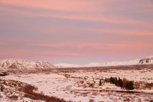
Close to the capital is the popular travel route known as the Golden Circle.
Many waterfalls, parts of the highlands, various national parks and glaciers are in the south of the island. You´ll find absolutely beautiful hiking and horseback riding paths. If you´re looking to enjoy the country a bit differently, you can take a trip by helicopter or a Super-Jeep tour.

Along the Ring Road (Street Nr. 1) are many sights. You can either drive from Reykjavík directly east on the Ring Road or you can drive via Mosfellsbær to the sights of the Golden Circle and turn onto the 1st street near Selfoss and head towards Höfn.
There are many outwash plains south of the glacier Vatnajökull. These are plains of sand, gravel and rubble. During heavy storms, parts of the Ring Road are closed because of the danger of sandstorms.
If you choose the route around the Golden Circle to travel to the south, you head from Reykjavík towards Mosfellsbær. An interesting stopover is the Álafoss shop, a manufacturer of Icelandic wool. Continue on to the national park Þingvellir. Along the way to Geysir, you´ll pass by the great swimming pool in Laugarvatn. After a side trip to the Gullfoss waterfalls, you´ll drive on the 35th street going south. Stop and see the gorgeous waterfall Faxi and the Kerið crater. Just before reaching Selfoss you´ll come to the Ring Road. From here you can continue towards the south or return to Reykjavík.
If you drive directly along the Ring Road from Reykjavík, you´ll first pass through a short desert, cross over a high mountain and continue 45 kilometres to Hveragerði. From far away, you´ll see the greenhouses that are heated by geo-thermal energy. In the middle of the town is a high temperature area. There is a field with hot springs. In some gardens there are steaming and hissing spots. The absolute highlight is the Reyjadalur, a valley with a hot river. After hiking for about an hour, you can take a warm bath in it.
From Hveragerði, it´s about a 15-minute drive to Selfoss, the biggest city in the south. You´ll find almost everything you need here: various shops, possibilities to spend the night, cafés and restaurants.
The city is very beautiful. Drive across the Ölfusá river and enjoy the ambiance and the contrast between water, nature and the city.
The community of Àrborg consists of Selfoss and two further towns to the south, Eyrarbakki and Stokkseyri. There you´ll find museums about seafaring people, history, organs, ghosts, trolls, elves as well as northern lights. The typical Icelandic houses, the black sand and the fishing tradition give these towns their unique charm.
If you want to experience horses in Iceland, then you are in the right place in Hveragerði, Selfoss, Hella and Hvollsvöllur. Many horse breeders and riding tour companies are situated here.
On the rivers around Selfoss you can enjoy the countryside by boat.
8 kilometres east of Selfoss is the Þingborg wool centre. Here you can discover how wool is processed. The attached shop sells products made of wool.
If you drive from Selfoss on the 1st in the direction of Hella and, after about 10 minutes, head towards the north on the 30th, you´ll reach Flúðir after around 25 minutes. This small town is well known for the beautiful countryside and for the Secret Lagoon, the oldest swimming pool in Iceland. Flúðir offer great golfing, hiking and horseback riding.
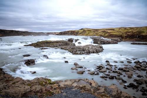
Back on the Ring Road, you reach the waterfall with the greatest amount of water in Iceland: the Urriðafoss. From there, continue on to Hella, from where you can reach the highlands and Hekla, one of the most well-known volcanoes worldwide, and the volcanic region Landmannalaugar.
Besides a few small shops and the Hekla centre, Hella is mainly interesting for horse fans. This is the home of a big riding facility where the largest riding competition in Iceland, the Landsmót, takes place every year. Many horseback riding tours are offered in this area.
The next village is Hvollsvöllur. This is where the Katla Global Geopark begins, with a size of 135 kilometres as the crow flies. Because of the tectonic plate drift, this area is strongly under the influence of volcanism. Many volcanoes, a few glaciers and a beautiful landscape mark the geopark. Hvollsvöllur is a small village with a saga centre and the biggest volcano and earthquake exhibition in Iceland. From Hvollsvöllur you can take helicopter and Super-Jeep tours to and across the Highlands.
Continue on towards Vík. After about 20 kilometres you can decide to take the ferry to the Vestmannaeyjar islands.
This group of islands, with the main island Heimaey, formed around 70,000 to 100,000 years ago. Little by little volcanic eruptions created new islands and cliffs. After the eruption from 1963 to 1967 the island Surtsey emerged. In 1973 there was a momentous eruption that buried houses on Heimaey under lava and ashes. Today you can enjoy the main island Heimaey in all of its splendor. The southernmost point Stórhöfði is a breeding area for puffins and also the windiest place in Europe. You´ll also find the volcano museum Eldheimar and a folk museum.
Leaving the island, returning to the Ring Road and continuing the route, you´ll soon see one of the most well-known waterfalls in Iceland, the Seljalandsfoss. You can walk behind the waterfall with a height of 60 metres. After a further drive of about half an hour along the main traffic route, you´ll reach the next sight, the waterfall Skógafoss.
Dyrhólaey is a few kilometres away from Vík. The peninsula reaching 115 meters high offers a great view across the sea and of the black cliffs called Reynisdrangar near Vík. When the weather allows it, you can see the southern coast and the glacier Mýrdalsjökull.
The hub between Reykjavík and Höfn is Vík. This town offers breathtaking scenery as well as a big rest stop, a wool company with attached shop, many places to spend the night, restaurants, cafés and a lot of things to see. According to a legend, three trolls, Skessudrangur, Landdrangur and Langsamur, wanted to pull a ship, that was in distress, on land. They were turned to stone by the rising sun. Today you can watch the three big cliffs in the water from the beautiful beach with black sand.
On the way to Kirkjubæjarklaustur you pass by the lava field Eldhraun. This field was created in 1783 by a devastating volcanic eruption. Ever since then, the rocky landscape has been overgrown by moss. During dry periods the moss is brown, after rainfalls it presents itself in bright green colours. The moss is very sensitive. When stepped on it can take up to 200 years to regain its original beauty.
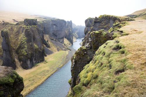
Shortly before reaching Kirkjubæjarklaustur, a sign on the left-hand side points to the Fjaðrárgljúfur gorge. After a short drive along the narrow street F206 you reach the foot of the gorge. From here an easy walk leads along the gorge and offers views 100 metres into the deep.
Kirkjubæjarklaustur is a very small town with a population of 126, but there is always something going on at the petrol station directly on the Ring Road.
The national park Skaftafell is situated 70 kilometres behind Kirkjubæjarklaustur. Countless tourists hike through the national park every day, walk to the waterfall Svartifoss, climb the glacier with a guide and enjoy sunrise and sunset while camping.
Continuing the journey towards the east, south of the glacier Vatnajökull, you reach a big sandy coast, the Ingólshöfdi. This 10 kilometre long beach is named after the first settler in Iceland, Ingólfur Arnarson. A big bird cliff is home to thousands of birds like the puffin and the skua.
The most well-known glacial lake in Iceland, the Jökulsárlón, is also the deepest lake in Iceland with a depth of 248 metres. Very many tourist, and also natives, marvel at the floating sheets of ice and maneuver their boats around them.
30 kilometres before reaching Höfn, you can drive to the glacial tongue Fláajökull. You turn off onto a small street and drive 20 minutes along the path to a parking lot and walk from there to the outer edge of the glacial tongue.
Höfn í Hornafirði is a city on the southeastern end of the Vatnajökull on a languet between two fjords. The name Höfn means port and that also marks the biggest economic factor of the town. Every day fishing boats leave the big port and return with fish and Norwegian lobster, also called langoustine. Because lobster is important for the region, it is celebrated every year in the summer with the langoustine festival. Next to the restaurants serving fish delicacies, you´ll also find small cafés, a campground, many places to spend the night, various museums, a swimming pool and a big supermarket.
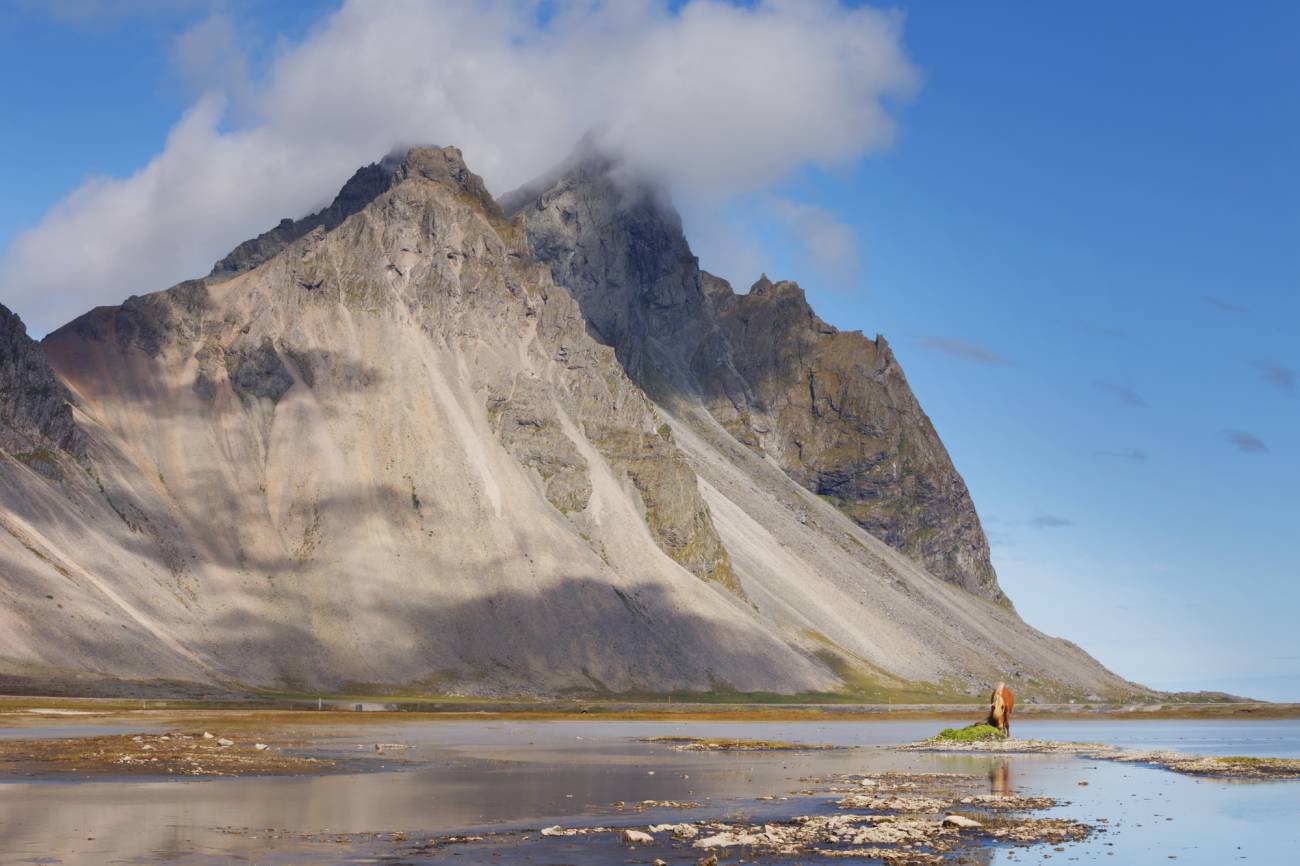
On the way to the east of Iceland, a few kilometres after Höfn, shortly before reaching the Almannaskarðsgöng tunnel, you´ll see signs to the Viking Café. Follow the well prepared dirt road for about 5 kilometres and you´ll find yourself in one of the most beautiful places in Iceland. The Viking Café, with its typically Icelandic interior, is a nice rest stop offering good coffee and tasty waffles as well as a small campground. You can take a walk along the black sand beach with a view of the massive mountain, Vestrahorn. Visit a Viking village and explore the old American radar station in Stokksnes from the outside. From the dunes near Stokksnes you have a phenomenal view of the mountains. A must-see for every photographer.
Driving through the tunnel towards Egilsstaðir, you´ll reach the next village, Lón, in a few kilometres. To the side of the glacier Vatnajökull lie the Stafafellsfjöll mountains. These have been under a comprehensive protection program for a long time. The mountains are very colourful due to rhyolithe rocks. In some of the lushly overgrown valleys you might see some reindeer.
Text & Bilder: Eva Frischling
Auszug aus dem Buch “Lebensgefühl Island” / “Soul of Iceland”
Eva’s website
Eva’s instagram
Eva’s facebook page
A land of fire and ice, with more sheep than inhabitants, characterized by a unique nature! This is just a brief description of such a diverse country. While a volcano may erupt on one side of the country, you can hike a glacier, admire the Northern Lights, or take a bath in a hot spring on the other side of the country - at the same time.
This not only speaks for diversity, but also for spontaneity, which is also reflected in the changeable weather in Iceland. A popular Icelandic saying is "If you do not like the current weather, just wait for five minutes".
In contrast to this inconsistency, one thing is constant and that is the enthusiasm for Icelandic horses! The Vikings brought horses to the island in the 9th century.
To find out more about Iceland, you can find travelogues, reports, or interesting facts here in the UNDRA Journal!